


Coordinator-Collect Coordinate

Coordinator-Collect Coordinate介绍
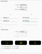
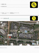
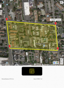
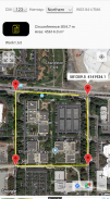
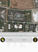
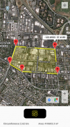
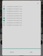
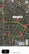
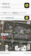
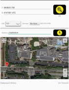
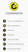
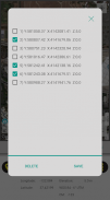
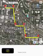
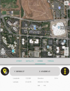
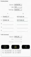
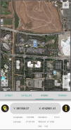
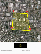
Using Coordinator app, you can collect coordinate data from land on whatever coordinate system you want, choosing from defined systems. You can collect GPS coordinates. You can view a coordinate data on the map and also you can search by address and see that on the map.(You can get directions to that point by clicking the red marker shown on the map). At the same time, you can learn the altitude value of the point and the distance between the point and your current location by long pressing on the map. Also you can see the distance and the elevation difference between two points created on the map. You can convert an existing coordinate into another coordinate system. You can do this by typing coordinates manually or opening an XLS file which contains coordinates. You can display circumference and area measurements of some coordinates by opening the file which created before using this app. Also you can measure circumference and area for some coordinates which determined manually on the map. Using this app, you can display a KML file on the map. Coordinator app contains several useful tools for people interested in coordinates, maps and geographic informations systems (GIS).
The coordinate systems of the countries, which the app is most downloaded, are added to the app.
Current list of the countries and their coordinate systems defined in this app:
World - GPS(WGS 84)
World - WGS 84 - 6 ̊ UTM
United States - "NAD 1983 HARN State Plane Coordinate Systems(meters & feet)" and "Military Grid Reference System (MGRS)"
Algeria - "Nord Sahara 1959 / UTM 6 ̊ "
Azerbaijan - "Pulkovo 1942 / Gauss-Kruger 3 ̊ " and "Pulkovo 1942 / CS63"
Bulgaria - "Pulkovo 1942(58) GK 6 ̊ "
Germany - "DHDN/3 ̊ GK" and "ETRS89 UTM 6 ̊"
India - "Kalianpur 1975 / India" and "Kalianpur 1975 / UTM 6 ̊"
Indonesia - "Indonesia 1974 UTM 6 ̊" and "DGN 1995 Indonesia TM3 ̊"
Iran - "ED50(ED77) / UTM 6 ̊"
Iraq - "Nahrwan 1967 / UTM 6 ̊" and "ED50 / Iraq National Grid" and "Karbala 1979 / UTM 6 ̊"
Israel - "Palestine 1923/Palest. Grid" and "Palestine 1923/Israeli CS Grid" and "Israel 1993/Israeli TM Grid"
Lebanon - "Deir ez Zor / Levant Ster." and "Deir ez Zor / Syria Lambert"
Mauritania - "Mauritania 1999 / UTM 6 ̊"
Morocco - "Merchich / Nord Maroc" and "Merchich / Sud Maroc"
Netherlands - "Amersfoort / RD New" and "Amersfoort / RD Old"
Palestine - "Palestine 1923/Palest. Grid" and "Palestine 1923/Israeli CS Grid" and "Israel 1993/Israeli TM Grid"
Philippines - "Luzon 1911 / Philippines" and "PRS92 / Philippines"
Romania - "Dealul Piscului 1930 / Stereo 33" and "Pulkovo 1942(58) / Stereo 70"
Russia - "Pulkovo 1942 / Gauss-Kruger 3 ̊"
Saudi Arabia - "Ain el Abd / UTM 6 ̊" and "Ain el Abd / Aramco Lambert"
Syria - "Deir ez Zor / Levant Ster." and "Deir ez Zor / Syria Lambert"
Turkey - "ITRF 96 - 3 ̊" and "ED 50 - 3 ̊" and "ITRF 96 - 6 ̊" and "ED 50 - 6 ̊"
United Arab Emirates - "Nahrwan 1967 / UTM"
使用Coordinator应用程序,您可以从定义的系统中选择所需的任何坐标系上从陆地收集坐标数据。您可以收集GPS坐标。您可以在地图上查看坐标数据,也可以按地址搜索并在地图上看到该数据。(您可以通过单击地图上显示的红色标记来获取到该点的路线)。同时,您可以通过长按地图来了解该点的高度值以及该点与当前位置之间的距离。您还可以看到在地图上创建的两个点之间的距离和高程差。您可以将现有坐标转换为另一个坐标系。您可以通过手动输入坐标或打开包含坐标的XLS文件来实现。您可以通过打开使用此应用之前创建的文件来显示某些坐标的周长和面积测量值。您也可以测量在地图上手动确定的某些坐标的周长和面积。使用此应用,您可以在地图上显示KML文件。协调器应用程序包含一些有用的工具,供对坐标,地图和地理信息系统(GIS)感兴趣的人使用。
该应用程序下载次数最多的国家/地区的坐标系已添加到该应用程序中。
在此应用中定义的国家及其坐标系统的当前列表:
世界-GPS(WGS 84)
世界-WGS 84-6̊UTM
美国-“ NAD 1983 HARN状态平面坐标系(米和英尺)”和“军事网格参考系统(MGRS)”
阿尔及利亚-“撒哈拉沙漠1959年/ UTM6̊”
阿塞拜疆-“ Pulkovo 1942 / Gauss-Kruger3̊”和“ Pulkovo 1942 / CS63”
保加利亚-“ Pulkovo 1942(58)GK6̊”
德国-“ DHDN /3̊GK”和“ ETRS89 UTM6̊”
印度-“ Kalianpur 1975 /印度”和“ Kalianpur 1975 / UTM6̊”
印度尼西亚-“印尼1974 UTM6̊”和“ DGN 1995印尼TM3̊”
伊朗-“ ED50(ED77)/ UTM6̊”
伊拉克-“ Nahrwan 1967年/ UTM6̊”和“ ED50 /伊拉克国家电网”和“ Karbala 1979年/ UTM6̊”
以色列-“巴勒斯坦1923 /巴勒斯坦网格”和“巴勒斯坦1923 /以色列CS网格”和“以色列1993 /以色列TM网格”
黎巴嫩-“ Deir ez Zor / Levant Ster”。和“ Deir ez Zor /叙利亚兰伯特”
毛里塔尼亚-“毛里塔尼亚1999 / UTM6̊”
摩洛哥-“ Merchich / Nord Maroc”和“ Merchich / Sud Maroc”
荷兰-“阿默斯福特/ RD新”和“阿默斯福特/ RD旧”
巴勒斯坦-“巴勒斯坦1923 /巴勒斯坦网格”和“巴勒斯坦1923 /以色列CS网格”和“以色列1993 /以色列TM网格”
菲律宾-“吕宋1911年/菲律宾”和“ PRS92 /菲律宾”
罗马尼亚-“ Dealul Piscului 1930 /立体声33”和“ Pulkovo 1942(58)/立体声70”
俄罗斯-“ Pulkovo 1942 / Gauss-Kruger3̊”
沙特阿拉伯-“艾因阿布德/ UTM6̊”和“艾因阿布德/ Aramco Lambert”
叙利亚-“ Deir ez Zor / Levant Ster”。和“ Deir ez Zor /叙利亚兰伯特”
土耳其-“ ITRF 96-3̊”和“ ED 50-3̊”和“ ITRF 96-6̊”和“ ED 50-6̊”
阿拉伯联合酋长国-“ Nahrwan 1967 / UTM”
Coordinator-Collect Coordinate - 版本7.7.1
(18-03-2025)
Coordinator-Collect Coordinate - APK信息
APK版本: 7.7.1程序包: com.suleymaner.coordinatorplusCoordinator-Collect Coordinate的最新版本


同类应用


